


VERNET Col de Mario . Les Béliers o

RobinMicheline
User GUIDE
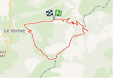

Length
10 km

Max alt
1811 m

Uphill gradient
605 m
Km-Effort
18 km

Min alt
1229 m

Downhill gradient
608 m
Boucle
Yes
Creation date :
2019-10-28 08:13:13.617
Updated on :
2020-01-22 17:27:36.165
6h09
Difficulty : Medium

FREE GPS app for hiking
 SityTrail
IGN / Geographical institutes
SityTrail Plus
The world is yours!
About
Trail Walking of 10 km to be discovered at Provence-Alpes-Côte d'Azur, Alpes-de-Haute-Provence, Le Vernet. This trail is proposed by RobinMicheline.
Description
belle vue sympa
Positioning
Country:
France
Region :
Provence-Alpes-Côte d'Azur
Department/Province :
Alpes-de-Haute-Provence
Municipality :
Le Vernet
Location:
Unknown
Start:(Dec)
Start:(UTM)
293593 ; 4906161 (32T) N.
Comments